
Dineo Storm Likely to Hit Mozambique Tonight as Cyclone, Kruger Thursday Night
The latest update on Dineo, the Severe Tropical Storm which is expected to hit the Kruger National Park later this week, is that its track has become more westerly and it is likely to reach Tropical Cylone status within the next six to 12 hours before making landfall in Mozambique this evening. According to Kevin Rae, Chief […]

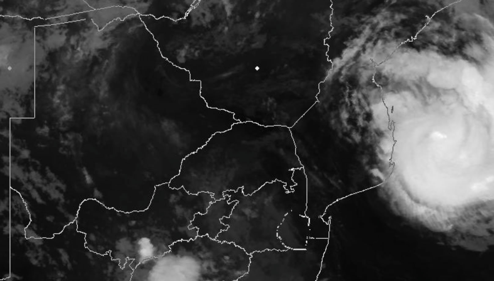
The latest update on Dineo, the Severe Tropical Storm which is expected to hit the Kruger National Park later this week, is that its track has become more westerly and it is likely to reach Tropical Cylone status within the next six to 12 hours before making landfall in Mozambique this evening.
According to Kevin Rae, Chief Forecaster at South African Weather Services (SAWS): “Dineo is really living up to the notoriously fickle and unpredictable nature of such tropical systems…
“The new [westerly] track will take the system on to the coast early this evening, near Massinga, somewhat north of Inhambane.”
He says Dineo is likely to undergo a “final surge of intensification, just before arriving over land and there is a good chance that it will reach Tropical Cyclone status within the next 6 to 12 hours.”
The projected maximum strength of surface winds associated with the system will be 70 knots, or about 130km/h… which has the potential to cause much damage.
“An obvious concern for communities in southern Mozambique will be heavy or torrential rain resulting in widespread flooding,” says SAWS.
Sea conditions along the southern Mozambican coast are forecast to be very rough, with waves up to 8 metres, and the threat of a marine storm surge… particularly along the coastline north of Xai-Xai.
On Thursday, 16 February, Dineo (which will be overland in southern Mozambique) is expected to migrate due west along 23 degrees south latitude, still as a significant rain-bearing system but starting to weaken significantly, says SAWS.
Southern Mozambique can expect about 100 to 200mm per day. The region around the lower portion of the Limpopo River is likely to be most affected with the risk of flooding.
The ‘good news’ is that, as with all such tropical systems, the moment Dineo moves overland it will undergo rapid structural weakening and decay as it is dependent on the open ocean as a source of latent heat energy to sustain its growth.
The impact of Dineo for South Africa is forecast to be:
SAWS says: “Heavy rainfall may occur in places over the northern lowveld and adjacent escarpment regions of Limpopo on the evening of Thursday the 16th.
“The greatest impact (with respect to South African provinces) is suggested to be overnight Thursday and into the morning hours of Friday the 17th, when heavy rain can be expected over the entire eastern half of Limpopo (including the Kruger National Park), where 100 to 200mm of rain could occur per day.
“By early Friday morning the surface vortex (core) of Dineo should begin dissipating in the region of Musina and Beit Bridge (Figure 2) in the northern part of Limpopo province.
“By Saturday the 18th, the remnants of Dineo are expected to drift into Botswana, showers are expected to continue over Limpopo Province. Rivers in the region will continue to flow quite strongly in the latter part of the weekend and into next week, as overland runoff takes some time to enter river systems.”
Updated information can also be found at www.weathersa.co.za as well as via the SA Weather Service Twitter account @SAWeatherServic