WARNING to South Africans Ahead of “Dineo” – Stay Safe!
PRETORIA – The South African government has called on communities to be on high alert and take precautions ahead of tropical cyclone “Dineo’s” arrival in the country later today. This after the South African Weather Service (SAWS) issued a warning of the anticipated Dineo which hit the coast of Mozambique (Gaza and Inhambane Provinces) on Wednesday accompanied […]

PRETORIA – The South African government has called on communities to be on high alert and take precautions ahead of tropical cyclone “Dineo’s” arrival in the country later today.
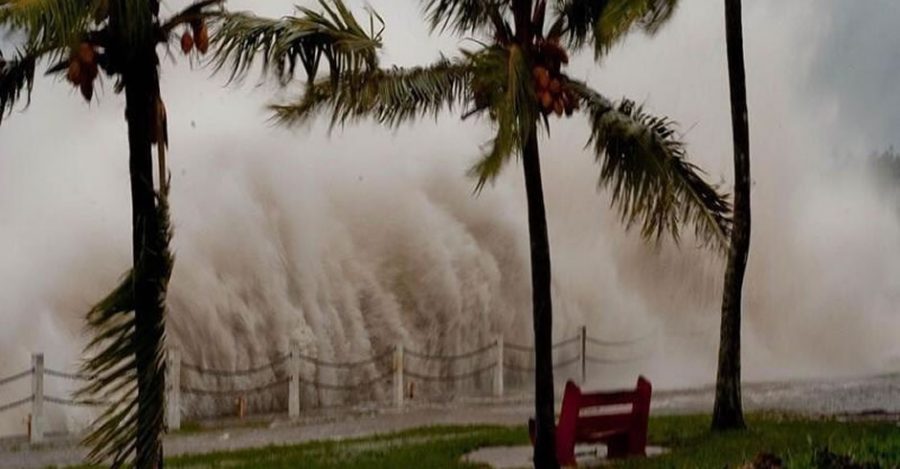
This after the South African Weather Service (SAWS) issued a warning of the anticipated Dineo which hit the coast of Mozambique (Gaza and Inhambane Provinces) on Wednesday accompanied by high seas, strong winds, storms and heavy rain.
The tropical storm is expected to reach Limpopo, Mpumalanga and the extreme northern parts of KZN.
Adriaan Groenewald reported from the Kruger this morning that there were already strong winds last night. “Now it is mostly a lovely rain descending on Marloth & Kruger National Park,” he tweeted. See videos below.
SAWS issued a statement Thursday saying winds had exceeded 100km/hour and torrential rainfall was estimated to be at least 100mm, if not over 100mm.
The weather system is now a tropical depression, named ex-Dineo to denote that the formerly marine storm system is now located over land.
Although the system is weakening over land, it sill poses “a great risk for the next 36 to 48 hours, particularly in terms of further exceptionally heavy rainfall and resultant flooding.”
SAWS said while the greatest threat today will no doubt be over the entire southern Mozambican region, there is also an increasing risk of heavy showers and thunderstorms over the lowveld and escarpment regions of Mpumalanga and Limpopo today, especially towards evening and overnight, when very heavy rain, of the order of 100 to 200mm can be expected over the eastern half of Limpopo province, continuing into tomorrow, Friday, 17 February. (Please see Flood Safety Tips below.)
In the latter half of Friday, patches of heavy rain may also occur over the western parts of Limpopo province as well as northern Botswana, as the remnants of the low track progressively further westwards over the African subcontinent.
By Saturday, patches of heavy rain occurrence could even persist over the northern parts of Namibia and Botswana respectively.
The Department of Cooperative Governance (CoGTA) has urged parents and guardians to ensure safety of their children as South Africa is set to experience severe storms and heavy rains starting from today until the weekend.
The department said it is important to ensure that children are safe and do not cross flooded roads, bridges and rivers in case of going to school.
The areas most likely to be affected in South Africa are: Kruger National Park, Enhlanzeni, Vhembe, Mopani and Waterberg district Municipalities.
The tropical storm will lead to flooding that might cut off many communities, displace others, lead to loss of life, destruction of infrastructure and property.
“It is important to note that the amount of rain and the speed of wind expected will have disastrous impact on communities and areas in which the cyclone will pass through.
“Even though Limpopo Province will be the worst affected, the impact of the storms and heavy rains might also be experienced in other provinces and areas as the rivers flowing from affected areas might lead to flooding somewhere else,” said the department.
Contingency plans
The department said government across the three spheres is working on contingency plans to ensure a coherent, integrated and coordinated response.
Preferably, communities should try at all cost to stay home during this period to avoid injuries as it is envisaged that there will be debris flying around and due to heavy rains and storms, visibility will also be poor.
It is expected that these storms might negatively affect normal life as power and water supply might be interrupted, roads flooded and bridges washed away.
Communities are requested not to cross flooded roads, low lying bridges and rivers; and to be especially cautious at night.
“Just six inches of fast-moving flood water can knock a person off their feet, and a depth of 2 feet is enough to float a car. Never try to walk, swim or drive through fast-moving flood water. Stop, turn around and go another way,” said the department.
Special warnings
Members of the public have been advised to listen to the special warnings on radio and/or television; abandon their home immediately guided by relevant authorities if evacuation is recommended, before access is cut off by flood water.
“In cases where other people are displaced, we request community members to assist one another guided by the principles of Ubuntu, especially those that would have been displaced by the sheer force of the cyclone.
The South African Weather Service and all other teams dealing with disaster management will continue to monitor any further developments relating to this weather system.
“Updates will be issued as and when necessary through various communication channels. Government urges communities to regularly follow developments through Radio, TV and other communication channels as this will assist to keep them safe.”
Sources: SAWS and SAnews.gov.za
#Dineo | Limpopo on high alert for tropical depression #Dineo Read More: https://t.co/bEqyYSYPih #SABCNews pic.twitter.com/yvXHjUfPnr
— SABC News (@SABCNews) February 16, 2017
The impact of the cyclone will also be felt on the city of Maputo, with rains up to 50 millimeters in 24 hours. #Dineo #sabcnews pic.twitter.com/q1BzxvsnNl
— Mweli Masilela (@mwelimasilela) February 16, 2017
Down at the Crocodile River. Calm but muddy…light rain at the moment. No doubt more heavy rains coming. #Dineo pic.twitter.com/VXo4EZeBl0
— Adriaan Groenewald (@AdriaanG_LP) February 16, 2017
Rain across #KrugerNationalPark intensifying. #Dineo Cyclone… @RichSimmondsZA @News24 @SAWeatherServic pic.twitter.com/l0eKYODEeg
— Adriaan Groenewald (@AdriaanG_LP) February 16, 2017
Dineo seen approaching Mozambique on Tuesday, 14 February 2017:
https://twitter.com/BawsePlaya/status/832156786270539776
AS THE MAJOR RISK ASSOCIATED WITH THE STORM WILL NOW BE FLOODING, THE FOLLOWING SAFETY TIPS NEED TO BE ADHERED TO DURING FLOODING:
- Do not try and cross flooded rivers or lakes.
- About 66 % of flood deaths occur in vehicles, and most happen when drivers make a single, fatal mistake trying to navigate through flood waters. Even 4×4 vehicles are not safe under these conditions.
- Do not drink floodwater since it may be polluted.
- Stay away from collapsed power lines and cables after a flood as live electricity could still pass through them.
- Turn off the electricity during a flood, because water is a good conductor of electricity and could cause electrocution.
- Store away clean drinking water and food.
- Listen to weather reports and instructions of local disaster managers. If necessary, evacuate the area.
AFTER A FLOOD
- Listen for news reports to learn whether the community’s water supply is safe to drink.
- Avoid floodwaters; water may be contaminated by oil, gasoline, or raw sewage. Water may also beelectrically charged from underground or downed power lines.
- Avoid moving water.
- Be aware of areas where floodwaters have receded. Roads may have weakened and could collapse under the weight of a car.
- Stay away from downed power lines, and report them to the power company.
- Return home only when authorities indicate it is safe.
- Service damaged septic tanks, cesspools, pits, and leaching systems as soon as possible. Damaged sewage systems are serious health hazards.
- Clean and disinfect everything that got wet. Mud left from floodwater can contain sewage and chemicals.