BRRRR! Snow, Icy Hail and Rain Storm into South Africa
As predicted by the South African Weather Service (SAWS), parts of South Africa have been hit by an intense cold front yesterday and today (Wed and Thurs 10-11 June 2020). Many Capetonians awoke to a scene that looked like snow… but was in fact bucket-loads of hail. Whilst in other parts of the Western Cape, […]

As predicted by the South African Weather Service (SAWS), parts of South Africa have been hit by an intense cold front yesterday and today (Wed and Thurs 10-11 June 2020).
Many Capetonians awoke to a scene that looked like snow… but was in fact bucket-loads of hail.


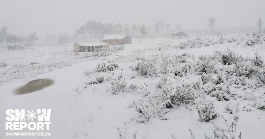
Whilst in other parts of the Western Cape, residents were treated to mountains of actual snow.
https://www.facebook.com/snowreportsa/posts/2811989928928343/
SAWS posted a satellite image of the cold front over the central interior of SA this morning. The weather service announced “very cold temperatures” across the western, central and southern parts of the country, and warned of heavy showers still being possible over the Western Cape with snow on the mountains.

Snow Report SA reported that Gydo pass between Ceres and the Koue Bokkeveld, the Theronsberg pass on the R46, and the Bo Swaarmoed pass towards Matroosberg Reserve have been closed to traffic “due to snowfall making the conditions very difficult for driving”.
Snow Report and Reenval SA shared the following photos and videos from their (freezing) followers around South Africa:
You can also catch the snow on the webcams at https://mydorpie.com/webcams and https://snowreport.co.za.
https://www.facebook.com/snowreportsa/videos/276094103505485/
https://www.facebook.com/snowreportsa/posts/2811849728942363/
https://www.facebook.com/snowreportsa/photos/a.312313212229373/2811818982278771/
The #Riviersonderend mountains in the WC covered in #snow. Magnificent sight.📹Charne Williams with permission.@sabcnuus @SnowReportSA @ewnreporter @News24 @sawx_sa_weather @SAWeatherServic pic.twitter.com/clzXtnhMuO
— ReenvalSA (@ReenvalSA) June 11, 2020
Sunette Ludick send us this video of thick black clouds rolling in over Paradise Beach at Langebaan followed by small hailstorm. #hailstorm @ewnreporter @Die_Burger @maroelamedia @sawx_sa_weather @sabcnuus @SAWeatherServic pic.twitter.com/lkRhWiggZK
— ReenvalSA (@ReenvalSA) June 11, 2020
#Funnelcloud seen near Gordonsbay, WC earlear this morning. 📹Andrew Reynolds.@ewnreporter @sabcnuus @Die_Burger @sawx_sa_weather @sawx_sa_weather pic.twitter.com/IfwREInxB8
— ReenvalSA (@ReenvalSA) June 11, 2020
BTW – this video which has been going viral on social media and WhatsApp is NOT from this week in Cape Town. It is old footage from 2018:
https://www.facebook.com/rian.laubscher.5/videos/4534602086557241/
SAWS says there will be more “disruptive snowfalls expected over the western high grounds of the Western Cape, the southern high grounds of the Northern Cape as well as the southern Drakensberg” on Friday morning.
AND high seas with wave height in excess of 6 metres are expected between Cape Columbine and Port Alfred in the morning.
Special weather advisories have been issued for “very cold conditions” in places over the eastern parts of the Northern Cape, the Free State… and “severe frost” expected over the Free State, in places over the eastern parts of the Northern Cape as well as over the southern parts of the North-West Province Saturday and Sunday.