SAWS issues multiple weather alerts across several provinces
Curious about what the skies hold? Discover the latest outlook for all nine provinces across South Africa this Friday, 14 November 2025.

Get daily updates on temperatures, winds and UVB levels, and see what the SA Weather Service predicts for the country.
Here’s the weather outlook for South Africa’s nine provinces.
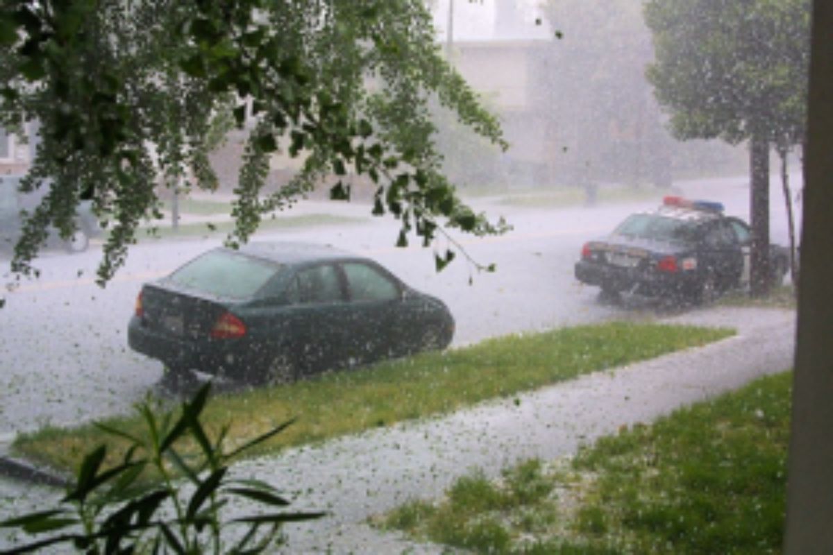
An intense spell of severe weather is expected across large parts of South Africa on Saturday, 15 November, with the South African Weather Service issuing multiple warnings. An orange level 5, 2, and 6 alert has been issued for several provinces.
SEVERE WEATHER ALERTS
IMPACT-BASED WARNINGS FOR SATURDAY
A. Orange level 5 warning: Severe thunderstorms leading to flooding of susceptible roads, low-lying areas and bridges, as well as loss of infrastructure, livelihood and livestock can be expected over the western parts of the North West, the extreme north-eastern parts of the Northern Cape, as well as most parts of the Free State, except the north and southern parts.
B. Yellow level 4 warning: Severe thunderstorms with heavy downpours, excessive lightning, damaging winds and hail resulting in injuries and danger to life due flooding of roads, settlements and low-lying areas, major travel disruptions and incidents, damage or loss of infrastructure, settlements (formal and informal) livelihood, agricultural production and livestock are expected in the central and western parts of KwaZulu Natal.
C. Yellow level 2 warning: Severe thunderstorms leading to localized flooding of susceptible roads, low lying areas and bridges as well as localized loss of infrastructure livelihood and livestock can be expected over the northern and southern parts of the Free State, eastern parts of the North West, the north-eastern parts of the Northern Cape, Gauteng, southern parts of Mpumalanga, extreme north eastern parts of the Eastern Cape as well as along the coast and adjacent interior of KwaZulu-Natal.
FIRE DANGER WARNINGS
Extremely high fire danger conditions are expected over the Bergrivier, Swartland and Matzikama Municipalities of the Western Cape.
ADVISORIES
NIL
IMPACT-BASED WARNINGS FOR SUNDAY
A. Orange level 6 warning: Severe thunderstorms leading to flooding of susceptible roads, low-lying areas and bridges as well as loss of infrastructure and livelihood, can be expected over the western Highveld of Mpumalanga as well as Gauteng.
B. Yellow level 4 warning: Severe thunderstorms with heavy downpours, excessive lightning, damaging winds and hail resulting in injuries and danger to life due to flooding of roads, settlements and low-lying areas, major travel disruptions and incidents, damage or loss of infrastructure, settlements (formal and informal) livelihood, agricultural production and livestock are expected over the northern parts of KwaZulu-Natal.
C. Yellow level 2 warning: Severe thunderstorms leading to localised flooding of susceptible roads, low-lying areas, and bridges, as well as localised loss of infrastructure, livelihood and livestock can be expected over Limpopo as well as the Lowveld and escarpment of Mpumalanga.
Weather conditions and UVB forecast in South Africa’s provinces
Gauteng
Gauteng can expect partly cloudy and cool to warm, becoming cloudy with scattered showers and thunderstorms from the evening.
The expected UVB Sunburn Index is Moderate
Mpumalanga
Mpumalanga, The Place of the Rising Sun, can expect cloudy and cool to warm with isolated showers and thundershowers, except in the Lowveld, where it will be hot.
Limpopo
In Limpopo, it will be cloudy and warm to hot with isolated showers and thundershowers, except in the Lowveld and Limpopo Valley.
North West
North West, known as Bokone Bophirima in Setswana, can expect cloudy and cool to warm with widespread showers but scattered in the extreme east.
Free State
In Free State, cloudy and cool to warm with widespread showers, but scattered showers can be expected in the south.
Northern Cape
The day will start fine and hot in the extreme west, otherwise cloudy and cool to warm with isolated showers and thundershowers, but scattered in the north east. The wind along the coast will be fresh to strong southerly to south-easterly.
Western Cape
Fine in the west, otherwise partly cloudy to cloudy and warm to hot, but cool over the southern parts where the will be light rain. The wind along the coast will be fresh to strong southerly to south-easterly, but moderate southerly to south-westerly along the south coast.
The expected UVB sunburn index is Very High.
Eastern Cape
The Western half: The day will be partly cloudy and warm in places; otherwise, it will be cloudy and cool with a chance of light rain in southern areas and isolated showers and thundershowers in the north. Winds along the coast will be moderate to fresh south-westerly.
The Eastern half: The day will start cloudy and cool, with scattered showers and thundershowers becoming widespread over the northern and eastern regions. Along the coast, the wind will be fresh and south-westerly.
KwaZulu-Natal
KwaZulu-Natal can expect Morning fog in places in the northern interior, otherwise partly cloudy and cool to warm, but hot in the extreme north-east. It will become cloudy from the afternoon with widespread showers and thundershowers. The wind along the coast will be moderate to fresh northerly to north-easterly, becoming moderate to fresh south-westerly in the south by mid-morning, spreading to Kosi Bay while reaching strong in places in the afternoon.
The expected UVB Sunburn Index is Moderate.
Forecast data provided by the South African Weather Service.