Watch Out Western Cape! Weather Warning for the Weekend!
The South African Weather Service (SAWS) has issued a weather warning for the Western Cape as an intense cold front is predicted to hit South Arica on Friday afternoon, resulting in adverse weather conditions in the Western Cape – including gale force winds, some flooding and snow. SAWS says strong westerly to north-westerly winds (40 […]
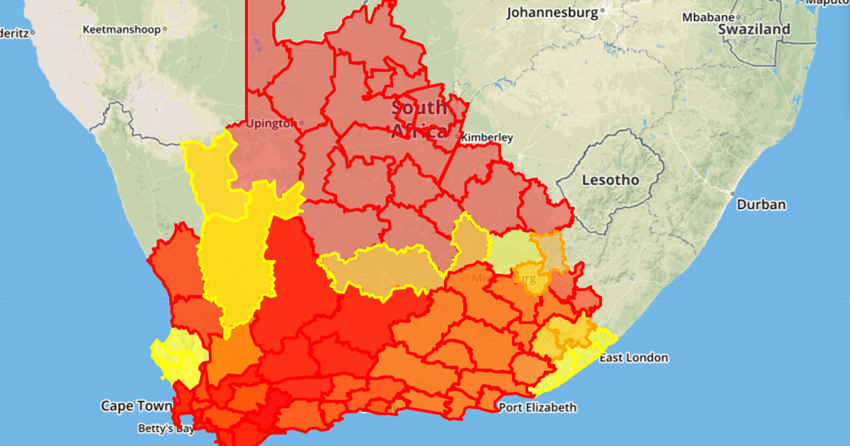
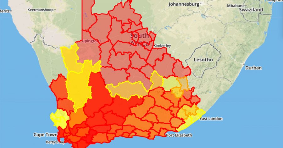
The South African Weather Service (SAWS) has issued a weather warning for the Western Cape as an intense cold front is predicted to hit South Arica on Friday afternoon, resulting in adverse weather conditions in the Western Cape – including gale force winds, some flooding and snow.

SAWS says strong westerly to north-westerly winds (40 – 60 km/h) can be expected
from Friday morning (21 June) onwards over the entire Western Cape Province, ahead of the arrival of the cold front.
Gale force winds…
Gale force winds (60 – 75 km/h, gusting 80 – 100 km/h) can also be expected in places over the Central Karoo, Breede River Valley districts and Cape Peninsula.
Gale force winds are also anticipated on Friday along the coast between Table Bay and Plettenberg Bay. SAWS warned that these strong, gusty winds may result in damage to settlements and infrastructure, transport routes and travel services being affected by falling trees, blowing dust as well as strong crosswinds, which could lead to longer travel times, as well as closure of susceptible and key routes.
Heavy Rainfall
At around midday on Friday, showers are expected to set over the Western Cape Province, spreading inland and eastward over most of the province during the afternoon and evening. It is anticipated that the majority of the rain will fall over the western parts of the province where 20 – 30 mm is expected on Friday, however rainfall in mountainous areas could peak as high as 40 – 50 mm.
Periods of heavy downpours may occur, which could lead to localised flooding. Informal settlements on the Cape Flats and the Overberg District are likely to be amongst the areas most vulnerable to flooding.
Snowfall
Snowfalls are also likely over the southern mountains of the Western Cape on Friday night to Saturday morning.
High seas
High seas (exceeding 6 m) are expected to reach the south-western coastline of the Western Cape by Friday evening, spreading eastwards and reaching the southern coast of the Eastern Cape, as far east as Port Elizabeth, by Saturday morning. Commercial and subsistence fishing communities along that coastline (especially the squid industry) are strongly urged not to venture out to sea on Friday evening, as sea (and wind) conditions are expected to deteriorate dramatically overnight into Saturday morning and afternoon, therefore posing a significant risk to life.
On Saturday rain and showers will persist along the south coast and adjacent interior of the Western Cape, spreading to the Eastern Cape by the evening.
Brrrrrr
The public can also expect cold to very cold temperatures to set in over the south western parts (including the Western Cape, Northern Cape, northern and south western interior of the Eastern Cape and south western Free State) on Saturday.
SAWS said in a media release that as the cold front shifts to the northeastern part of South Africa on Sunday, showers can be expected along the southeastern and eastern coastline, together with cold to very cold conditions over a large part of the interior of the country, where heavy frost can be expected Sunday night.
In the media release, compiled by Edward Engelbrecht and Thabisile Ntleko, SAWS said the public should take heed of the following watches:
- Heavy rain is expected over Cape Winelands, Overberg and Cape Metropole of the Western Cape on Friday.
- Localised urban flooding is expected over Cape Winelands, Overberg and Cape Metropole of the Western Cape on Friday.
- Strong to gale force winds are expected over the Central Karoo District, Breede River Valley and along the coastal regions between Cape Point and Plettenberg Bay on Friday, spreading to Port Alfred and the adjacent interior on Saturday.
- High seas with wave heights in excess of 6 m is expected between Cape Point and Cape Agulhas on Friday evening, spreading towards Port Elizabeth on Saturday morning.
- In addition, there is also an advisory for very cold conditions (daytime temperatures less than 10 °C) over the southern Namaqua district, Northern Cape as well as the Cape Winelands and Central Karoo regions of the Western Cape on Saturday.